Location
Down a narrow gravel road in eastern Wayne County lies a small community nestled within the mountains of Appalachia. Ritner is a very unknown community that is overlooked by many, as it's not easy accessible to most, and is difficult to navigate. After traveling over half the state in the past year, I have never seen an area that beats the beauty of Ritner. It is one of the most unique, and alien like areas I have ever visited. It is a gift to the state of Kentucky that is criminally underrated and overlooked by many. If you haven't been to Ritner yet, it's worth the trip.
Geography
The geographic features in Ritner is a beauty that is overlooked by many travelers passing through the area. As you approach the area of Ritner, you'll start to notice limestone jutting out of the ground in grassy fields. Although this is common across Kentucky, it is more apparent here. This natural occurrence is called "karst geography". Karst is a word that refers to areas that are prone to sinkholes, caves, and underground springs. Here is a map from Chuck Sutherland showcasing the frequency in karst landscapes and caves in KY. As you can see, eastern Wayne County is fairly cave ridden and karst.
https://www.flickr.com/photos/chucksutherland/23901437858/in/photostream/
The closer you get to Ritner, the larger and larger the cliffs and mountains become. These mountains aren't your typical Kentucky foothills. These are massive, rocky cliffs that stand tall and tower over anything in it's reach. The most notable mountains and cliffs are Tabletop Cliff, Denny Cliff, Sand Cliff, and Moody Cliff. A very interesting feature I noticed was a massive boulder, about the size of an SUV balancing on top of a cliff. It was such an interesting find, and I'm surprised not many others have heard about this.
The closer you get to Ritner, the larger and larger the cliffs and mountains become. These mountains aren't your typical Kentucky foothills. These are massive, rocky cliffs that stand tall and tower over anything in it's reach. The most notable mountains and cliffs are Tabletop Cliff, Denny Cliff, Sand Cliff, and Moody Cliff. A very interesting feature I noticed was a massive boulder, about the size of an SUV balancing on top of a cliff. It was such an interesting find, and I'm surprised not many others have heard about this.
Not only is Ritner rich in it's limestone cliffs, it also has multiple creeks and rivers running through the area. The Little South Fork river intersects with Lick Creek in Ritner. The Little South Fork river is a tributary that begins around 5 miles west of Parker's Lake. Lick Creek has a noticeable turquoise tint to the water, likely due to the minerals from nearby caves.
Lastly, as I was taking photos of the cliffs in Ritner, I noticed that there was audible rushing water under the ground. near the side of the road. This was quite interesting, considering that underground streams typically aren't audible through the soil.
Lastly, as I was taking photos of the cliffs in Ritner, I noticed that there was audible rushing water under the ground. near the side of the road. This was quite interesting, considering that underground streams typically aren't audible through the soil.
Notable Features
The Ritner Swinging Bridge is a small tourist attraction located in Ritner. As of now, it is closed to the public for repairs. The history of this bridge is obscure, but it is a gateway into the Daniel Boone National forest on the other side.
Photo Gallery

Ritner Balancing Rock

Denny Cliff
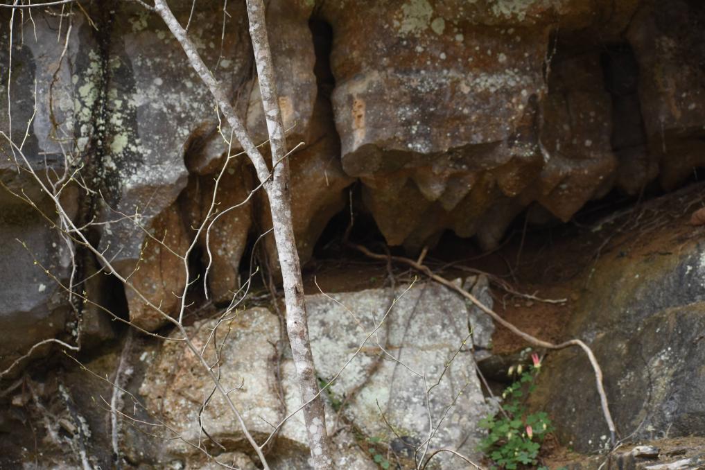
Stalagmites in a small cavern.

Ritner Swinging Bridge
Sources:
All Images Sourced from me.
topozone.com